Tasmania has at times left me speechless and at other times brought tears to my eyes with her beauty. She is more than I ever expected her to be. Admittedly, all I knew of her before I came here was of a cartoon devil from Loony Tunes that swirled in circles and had a short temper. Still, her mysteries had amazed me.
Our Lil’ Beaut
First things first, before I tell you about the spectacular East Coast of Tasmania, I need to let you know what we decided on a name for our new home. We had a lot of great suggestions but one of them just stood out.

Throughout the week we tried a few of them on for size as we were hiking, referring back to our home as “Don” or “Gandalf” and I even tried “My Precious’ which was suggested to keep with the LOTR theme, but I couldn’t keep from lowering my voice and rasping it out whenever I said it.
Beaut, as suggested by my friend Michael, just seemed to stick. We loved it not only because it is short and easy to say the entire reason behind the name was pretty cool.

Michael is also the Antarctica guide who got our zodiac close enough for an excellent picture of a Wendell seal that became the feature image of Blue Ice and Antarctica. Thank you, Michael!!
Tasmania East Coast
We will only have one full month in Tasmania and a week of that time was used to purchase Lil’ Beaut and get settled into our new home. The rest of this month will be spent exploring, not nearly enough time to see all that Tasmania has to offer but it will suffice.
We began our exploration of the east coast in Hobart. Hobart is the most populous city in Tasmania with 240,000 people, 40% of the Tasmanian population. This beautiful city is also the capital of this small island below mainland Australia. The city itself rests in Sullivan’s Cove and is watched over by the snow-capped peaks of Mt. Wellington.

Bruny Island
Bruny Island is 30 kilometers south of Hobart. A ferry leaves from Kettering multiple times a day towards Bruny and is only a 20-minute ride. We boon-docked (free camped) near Kettering so that we could catch the 7:30 AM ferry. The sky was gray and threatened rain but we hoped it would clear up for the hiking we had planned, but as we docked on Bruny Island the rain began followed by hail. We drove carefully hoping the windy roads would not turn to ice.
Cape Queen Elizabeth
After a 20-minute drive, we parked Lil’ Beaut at the trailhead across from The Honey Pot. We made lunch and packed it into our day pack. The entire sky cleared and became blue giving us a nice warm start to our hike.
The sun didn’t last long, the winds picked up and soon the blue was gone and menacing clouds hung over our heads, but we had our jackets, scarves and raincoats. We knew how unpredictable the roaring 40s could be. We decided to press on.
Just as we reached the first glimpse of the beach the sky let loose. We came to a fork in the trail that gave us the option of taking the beach trail or the trail that takes us up over the mountain to our ultimate destination. Since the beach trail could only be traversed during low tide we opted for the high road.

As soon as we started to climb it began to hail. Little ice balls pattered off our rain jackets and a frigid wind penetrated our layers causing us to shiver. The low shrubs along the trail did little to protect us from the winds. We kept climbing hoping the exertion would warm us up.
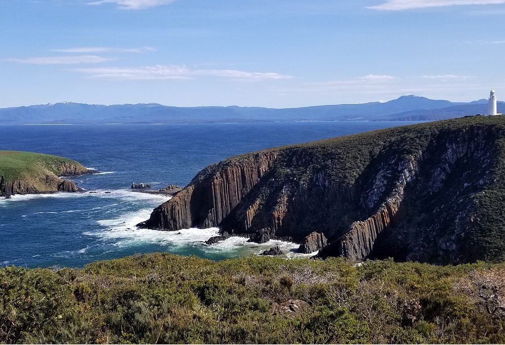
When we reached the top the sky cleared up. The winds were still strong and quickly dried us off. Soon we were stripping off layers and giddy with the views all around us. Below us lay secluded beaches of white sands and turquoise waters. In the distance, we could see the dramatic cliffs of the lower portion of Bruny island.
The entire weather scenario cycled through again, hail and all, but it was short-lived and we were glad that we pressed on.
These roaring 40’s winds can change everything within moments.
The Roaring 40’s
The Roaring 40’s is the current of air that roars through the 40th and 50th latitude lines in the Southern Hemisphere. It primarily crosses open ocean waters allowing it to pick up speed. The winds are a combination of air displaced from the equator but crosses currents from Antarctica. It can change the weather in moments on the small pieces of land that it does cross.

The first time I experienced the roaring 40’s was in Cape Town, South Africa. It was ages ago before digital cameras were a thing, but I did take a picture of my friend Kyle from college hanging on to some of the kids who were flapping in the wind. I had never felt anything like it before and never did again, until last year while in Patagonia – between the 40th to 50th latitude lines just below Chiloe in Chile around the Marble Caves.
Here in Tasmania is my third experience with it. Each time I’m amazed at its strength and unpredictability.
The only other land mass that these winds cross is New Zealand, something we hope to experience next year.
Finally, after all the season changes in just the short few hours hike out to Queen Elizabeth’s Cape we reached the end of the trail. Trin reached the top of the final mountain first. He looked back at me with this huge smile and waved me forward to hurry up and look at the view.
All along the way, the views were amazing, but the trail saved the best for last as we watched waves hit perpendicular cliffs below us. In front of us was the Queen Elizabeth monolith. A massive pillar of rocks rose regally straight out of the waters in its stance against the raging ocean.

The Honey Pot
After our hike, we crossed the road over to The Honey Pot. They sell products from locally harvested honey. They offer free tasting and educational displays on the walls about the bees. We could even open a little door to see live bees at work in a hive. They place beehives in various locations on the island to give the bees different plants to pollinate. Pollen from different plants will produce slightly different flavors and colors in the honey.
We tried a few different strains but settled on purchasing their honey/vanilla ice cream. The temperature of the ice cream was perfect, soft, but not too soft, and smooth, so smooth. I can highly recommend the ice cream and the honey from The Honey Pot.
The Neck
On the map, Bruny island almost looks like two islands, but they are connected by a sliver of land called “The Neck.” This connection is just wide enough for a road and a small beach on one side and a few shrubs and another beach on the other side.
We stopped at the beginning of the neck to climb several flights of steps up to the 360° viewpoint at the top of the hill. The viewpoint overlooks a nesting area for Little Penguins. Really that is their name, “Little Penguins.” They only come in at night after dusk and leave before dawn to feed all day.

Camping
Hotel Bruny has a large picnic area they call they beer garden. They allow self-contained vehicles to park overnight for $5AUD per night. We opted to stay here as most places on the island are quite pricey. The bartender was really friendly and even filled up our water bottles for us with fresh drinking water. We would end up staying here for the next two nights as well. It’s a great location and the staff is really wonderful. As a bonus, there’s a Big Bargain Bottle shop right next to it.
Adventure Bay
In the morning we drove over to Adventure Bay. There are seafood restaurants, accommodations, and much more, but we were more interested in the sights.
Fluted Cape and Grass Point
Grass Point is a nice easy one hour walk across a mostly flat trail. It starts on the beach and then follows the coastline past old whaling stations. At the end is a grassy area that one of the whaling billionaires used to call home. The views there are amazing. Just beyond grass point is a small island. Waves crash through the small opening between grass point and the small island in a beautiful spray of salty mist. We sat and watched the spectacle for quite some time.
Beyond the cove to our left in the distance, we could see the proud pillar of Cape Queen Elizabeth, from our hike the previous day.
From here the Fluted Cape trail begins as a steep ascent. The ascent doesn’t let up until we reached the top of the cliffs of the fluted peak. We stopped often to take pictures and take in the views the entire climb. Upon reaching the top I looked out over the vast ocean with no land in sight beyond. Something about the vast ocean is calming and calls to me.

Slide Track
Late that night as we prepared for our hike the following day on Slide Track we continued our research looking for reviews and advice from other hikers. Almost all of the reviews mentioned leeches. Some said, “poorly maintained and then you reach the slide, hikers beware.” One said, “You will get at least 30 leaches each from this hike.” In fact, almost all of the reviews mentioned the leeches and poor conditions. None of the reviews mentioned anything about beautiful views.
“This guy got a leach in his ear,” Trin exclaimed reading another review.
We decided to skip this track and instead head down to the lighthouse the next day. If anyone reading this has actually done this trek, please let us know in the comments below if you would do it again and if you felt it was worth it.
The road to Bruny Lighthouse
Our first Airbnb host in Tasmania before we purchased Lil’ Beaut gave us a wonderful introduction to Tasmania. After asking us how long we had on the island and what we hoped to do he pulled out a huge map and gave us an overview of all the wonderful things we could see. I recommend this Airbnb as the first stop in Tasmania. It is a clean, beautiful place. The free overview Daniel gives is better than any information center has given us to date. Daniel told us that the road from Alonnah down to the lighthouse on Bruny island was gravel. He told us that many people have gotten into trouble on this road. He himself has even had an accident on that road. Furthermore, most rental companies forbid drivers to take their rental cars on this road.
We inquired at the post office in Alonnah about the road conditions to see if it was safe for a 20- foot bus to navigate. Just as we were asking one of the road crew walked in.
“Yeah, it should be fine. They just graded the entire road. You will probably get muddy, but you will be fine,” he said.

Bruny Lighthouse
We gave it a go and drove to the bottom of Bruny Island. Parking at the caretaker’s home, we climbed out of Lil’ Beaut and walked up to the top of the cliff where the Bruny lighthouse stood tall and white still providing a warning to all ships of the dangers.
Whenever I see a lighthouse I always remember the little story about a ship with a high ranking captain who met with a lighthouse one foggy night. Seeing the light the captain radioed for the other “vessel” to change course. The lighthouse of course just responded with something like, no you move.
After giving his rank and title, again the commanding officer demanded that the other vessel move. The lighthouse keeper just responded with, “No, I’m a lighthouse. You move.”
It reminds me that no matter what we may have achieved in life, no matter our title or rank, we must all submit to the rock that is greater than us. The sheer size of the cliffs and the strength of the wind and waves constantly remind me of how small we really are.

After following all the trails around the lighthouse we headed out another dirt road to Jetty beach. The Luggaboine Circuit trail was our next destination. The road to Jetty beach looked like it would be precarious in the rain. We were happy to finish the trail and make it back out of there before the threatening clouds let loose again.
All this is just the start of Tasmania’s East Coast. The rest will have to wait for our next post.
While Lil’ Beaut doesn’t have a blue door, unlike my favorite car, she is still an opportunity for adventure for us. What will be your next blue door?
I’ve only been to Tassie for 3 days and that was about 20 years ago.
I remember standing on Mt Wellington in a snowstorm – in SEPTEMBER!!!
Crazy cold down there.
Your photos are great – I might zip down there again some time… but there’s an ex-boyfriend I’d have to avoid!!
September on Mt Wellington is COLD. I can’t wait to share the rest of what we are seeing. I’m so impressed.
Yes, avoid that ex, lol
The views in your pictures are absolutely stunning! As you stated, something about the ocean is so calming.
Thank you Jackie. I can’t wait to show you the views from further up the east coast
What an incredible adventure you are on. Nice name for the motorhome.
Cheers!
Thanks, the name just stuck and I couldn’t let it go 🙂
Great Story Bonnie
I have only been to Tasmania for work – I used to travel to Hobart regularly while i was designing and then supervising the build of a research facility for the University down there.
Beautiful part of the world.
Your Post makes me want to go and explore more of Tasmania outside of Hobart!
Keep enjoying your trip.
Shaun
Thanks Shaun, we will most likely end up listing Tasmania very high on our list of most beautiful places in the world
Thank you for sharing your blog post. I really enjoyed reading it and found the photography to be very refreshing. Thank you.